Sawpit, Colorado
Appearance
Sawpit, Colorado | |
|---|---|
 Sawpit Mercantile in Sawpit | |
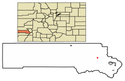
 Location of Sawpit in San Miguel County, Colorado. | |
| Coordinates: 37°59′41″N 108°00′04″W / 37.99472°N 108.00111°W | |
| Country | |
| State | |
| County[1] | San Miguel County |
| Incorporated | 1896[citation needed] |
| Government | |
| • Type | Statutory Town[1] |
| Area | |
| • Total | 0.03 sq mi (0.08 km2) |
| • Land | 0.03 sq mi (0.08 km2) |
| • Water | 0.00 sq mi (0.00 km2) |
| Elevation | 7,563 ft (2,305 m) |
| Population | |
| • Total | 38 |
| • Density | 1,300/sq mi (480/km2) |
| Time zone | UTC-7 (MST) |
| • Summer (DST) | UTC-6 (MDT) |
| ZIP codes[5] | 81430, 81435 |
| Area code | 970 |
| FIPS code | 08-68655 |
| GNIS feature ID | 2413263[3] |
Sawpit is a Statutory Town in San Miguel County, Colorado, United States. The town population was 38 at the 2020 census, making Sawpit the fifth least populous incorporated town in the state of Colorado.[4] The Telluride Post Office (ZIP Code 81435) serves Sawpit.[5]
Geography
[edit]According to the United States Census Bureau, the town has a total area of 0.031 square miles (0.080 km2), all land.
Demographics
[edit]| Census | Pop. | Note | %± |
|---|---|---|---|
| 1900 | 94 | — | |
| 1910 | 121 | 28.7% | |
| 1960 | 30 | — | |
| 1970 | 26 | −13.3% | |
| 1980 | 41 | 57.7% | |
| 1990 | 36 | −12.2% | |
| 2000 | 25 | −30.6% | |
| 2010 | 40 | 60.0% | |
| 2020 | 38 | −5.0% |
See also
[edit]References
[edit]- ^ a b "Active Colorado Municipalities". State of Colorado, Department of Local Affairs. Archived from the original on December 12, 2009. Retrieved September 1, 2007.
- ^ "2019 U.S. Gazetteer Files". United States Census Bureau. Retrieved July 1, 2020.
- ^ a b U.S. Geological Survey Geographic Names Information System: Sawpit, Colorado
- ^ a b United States Census Bureau. "Sawpit town, Colorado". Retrieved April 5, 2023.
- ^ a b "ZIP Code Lookup" (JavaScript/HTML). United States Postal Service. December 14, 2006. Retrieved December 14, 2006.
External links
[edit]Wikimedia Commons has media related to Sawpit, Colorado.

